
Outline Planning Application
Using the postal platform STANNP, a letter drop was posted to 631 residential addresses in the vicinity of the proposed development throughout w/c 22nd June 2026. The locations of the addresses are indicated in the images below.
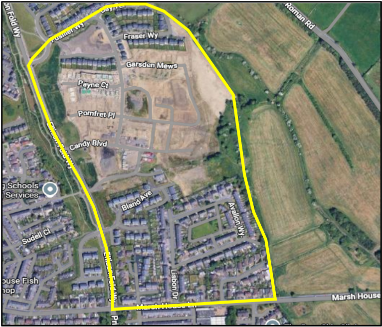
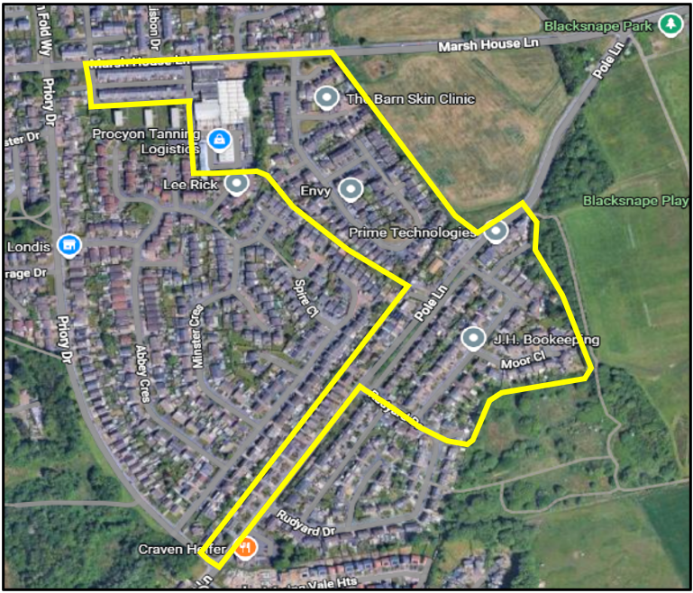
The letter briefly described the proposed development, and it directed recipients to this public consultation website. The website provided further details about the proposed development, the relevant environmental and technical considerations, and progress that has been made to date.
The letter and website allowed for feedback to be provided through the online form on the website, or by post to DLP Planning. The website and online form were live from 29th June 2026 until 24th July 2026
80 responses were received through the online feedback form, and 1 response was received by email. No responses were received by post.
No correspondence from the local community was received after the 24th July 2026.
All feedback received has been comprehensively reviewed, and the key themes raised in the feedback have been categorised in the table below:
| Key themes | Occurrence |
| Traffic / highway safety / site access | 63 |
| Pressure on local services / infrastructure | 50 |
| Loss of greenfield land and brownfield alternatives | 47 |
| Ecology | 40 |
| Housing need | 33 |
| Recreation and rights of way | 25 |
| Flood risk and drainage | 24 |
| Landscape impact | 21 |
| Ground stability | 15 |
| Housing mix / affordability | 15 |
| Residential amenity | 14 |
| Air quality | 7 |
The main issues raised by respondents, in relation to each of the key themes, are summarised under headings below. Responses to the feedback are also provided.
Traffic / highway safety / site access Requirements
- Concerns about the amount of potential impact on the existing road network in terms of increased traffic generation from the proposed development, because there is already congestion on Marsh House Lane, Pole Lane and Roman Road.
- Queries about whether the proposed vehicular access off Pole Lane will be safe and achieve sufficient visibility, because some respondents have seen drivers exceeding the speed limit on Pole Lane. Some suggestions were made that the Applicant should consider access from Marsh House Lane instead.
A Transport Assessment has been prepared and will be submitted as part of the planning application. The Assessment considers existing conditions and committed sites, accident data, potential traffic and trip generation, and the operational capacity of the existing highway network and how traffic from the development could impact the capacity. The Assessment also explains how the design of the vehicular access points was informed by (inter alia) various surveys including traffic and movement counts along Marsh House Lane and Pole Lane, and at the nearby junctions.
Traffic calming measures are incorporated into the design of the proposed access points.
Pressure on local services / infrastructure
- Already insufficient capacity at GPs, dentists, and primary and secondary schools.
- Local amenities are limited in Darwen.
- Public transport options are limited on Marsh House Lane and Pole Lane.
- There has been a decline in water pressure in the locality in recent years which is understood to be because of the nearby new residential developments, and some residents have concerns about the lack of sewage capacity.
- Local roads, including Marsh House Lane and Pole Lane, are in a poor condition with a large number of potholes.
The site is in a sustainable location, and it is allocated for residential development in the adopted Local Plan. The site being allocated means that the Local Planning Authority have already assessed the suitability of the location in terms of its sustainability credentials and have deemed it to be acceptable.
Financial contributions towards increasing the capacity of existing local services and infrastructure may be secured through a Section 106 Agreement if permission is granted.
The existing road network being in a poor condition is a matter for the Local Highway Authority who are responsible for maintaining adopted roads.
Loss of greenfield land and brownfield alternatives
Resistance to new development on Green Belt Land.
Loss of local open green space.
Brownfield sites within Darwen should be prioritised for residential development, over greenfield sites such as this.
Some residents feel that Darwen is at a saturation point and does not need any more houses, because there are already several other new build developments in the area that have not been completed yet / where some of the dwellings have not been sold yet.
The site does not form part of the Green Belt, it is not designated as green space, and it is in private ownership. It is allocated for residential development in the adopted Local Plan, which means that the principle of development in terms of land use has already been established as acceptable.
Ecology
- Various wildlife species (such as bats, badgers, rabbits, deer, and birds) are seen regularly on both parcels of land. Concerns that wildlife will be lost from the area if the proposed development comes forward.
- Concerns about the potential effect on mature trees and hedgerows, including trees covered by Tree Preservation Orders.
- Concerns that construction activity, habitat clearance, noise and additional lighting could disturb wildlife and reduce the value of the site (for feeding, nesting, roosting and movement).
A comprehensive Ecological Impact Assessment (with accompanying technical appendices in relation to protected species survey results), and a Biodiversity Net Gain Assessment, have been prepared and will be submitted as part of the planning application.
Provision of a Construction Environmental Management Plan will be a planning condition requirement at the reserved matters stage.
The development proposals will seek to protect and enhance mature trees and hedgerows wherever possible. The indicative site masterplans (which have been informed by an Arboricultural Survey and Impact Assessment) that will be submitted as part of the planning application demonstrate that it is possible to design a layout that will not adversely impact existing trees and hedgerows.
Housing Need
- Concerns about the area becoming overdeveloped because there has already been substantial housing growth in recent years in Darwen.
- Queries about whether there is demand and need for the proposed development, because some of the recent new build estates still have some unsold houses.
The dwelling houses that will be constructed will contribute towards meeting local housing needs. The site has been allocated for residential development in the adopted Local Plan for this specific reason.
Recreation and rights of way
- The fields have been used for years as a recreational resource for horse riding, dog walking, running, exercise and informal enjoyment of the countryside. Queries about what provision is being made for the people that use the site for recreation.
- Some support for the proposed retention of the Public Right of Way network and the provision of walking and cycling links. Requests for further connections between the development, Marsh House Lane, Pole Lane, and the surrounding path network.
- A group of residents on Avallon Way requested that consideration be given to re-directing the footpath running behind Avallon Way and Marsham Grove (because it is rarely used and could provide opportunities for anti-social behaviour).
The proposed development will seek to deliver recreational opportunities within the new public open space areas, and through the provision of a LEAP (a locally equipped area of play for children). The detailed design will be provided at the reserved matters stage.
The proposed development will retain and enhance the existing Public Rights of Way running through the site, including the route behind Avallon Way and Marsham Grove, to improve connectivity. The retention and enhancements, and the increased use that will result from the site being developed, will deter anti-social behaviour because of the increased visibility from people frequently using the Public Rights of Way network.
Flood and drainage
- The existing fields function as a natural soakaway, absorbing rainfall that would otherwise enter the local drainage system. Concerns that replacing the permeable ground with the proposed development will increase surface-water runoff and the risk of flooding to neighbouring and downstream properties.
- Already flooding and drainage problems in the area (on Ellison Fold Way, the Clearwater estate, and in the garden of a property on Beaumont Way) and issues with United Utilities (burst water mains and murky / cloudy water).
A Flood Risk Assessment and Drainage Strategy have been prepared and will be submitted as part of the planning application. The detail provided in the documentation demonstrates that the proposed development will not adversely impact the rate of surface water runoff from the site (in comparison to the existing greenfield runoff rate), nor will it increase the risk of flooding in the area, in accordance with national and local planning policy requirements.
United Utilities as the water provider are responsible for investigating and resolving any issues with the water mains and the colour of the water.
Landscape impact
- The application site and the surrounding fields are an attractive, natural, countryside buffer between existing developments. Concerns about the existing appearance being replaced by the proposed residential development..
- Suggested landscape mitigation measures. These included proposed tree planting, substantial green buffers, noise reduction, and upgraded rear boundary fences for properties adjacent to the proposed development.
This is an outline planning application with all matters reserved except for access. The detailed design and layout of the proposed dwellings, and an associated hard and soft landscaping scheme (which will include boundary treatments and landscape buffers, and the retention and enhancement of existing landscape features wherever possible), will be provided as part of the reserved matters application(s) in due course.
The indicative site masterplans, and the associated landscape strategy, that will be submitted as part of the planning application show how the site could be developed to provide on-site public open space, enhancements to existing planting and new planting, and landscape buffers
Ground Stability
- The area has a history of coal mining, and there are mine shafts and shallow workings beneath and close to the site. Queries about if the location of the historic mine shafts is being taken into account.
- Concerns about potential risks associated with historic underground workings in the area, because of some sink holes in the area in recent years (at the Taylor’s Green development off Pole Lane, for example).
- Queries about whether the circles marked in red on the indicative site masterplans are the historic mine shafts.
- Queries and concerns about whether the proposed location of the pond next to a historic mine shaft is suitable / could lead to water leakage into the shallow mine workings.
The proposed development has been informed by extensive Phase I and II Site Investigation Assessments, and Coal Mining Risk Assessments, to identify any presence of contamination, ground gas, and coal mining risks associated with the historic mine shafts. The Assessments also identified what mitigation and remediation measures are required for the site to be developed for housing. The Assessments will be submitted as part of the planning application.
Detailed investigations have also been undertaken to identify the locations of the historic mineshafts, and these have been marked in red on the indicative site masterplans. There will be no development zones around the identified locations.
The pond shown on the indicative site masterplan is an existing pond, and it is a requirement of the allocation in the Local Plan that the pond must be retained. No issues or concerns were raised during the process of the site being allocated, or in the subsequent pre-application discussions with the Local Planning Authority, about the pond’s proximity to a historic mine shaft..
Housing mix and affordability
The housing mix appears to be dominated by larger 3 and 4 bedroom properties that will not be suited to local needs.
Darwen needs more affordable homes, including Council houses and smaller houses for first time buyers and younger households.
Most of the new builds in the area are unaffordable for local people, and there are concerns that this proposed development will be unaffordable as well.
This is an outline planning application with all matters reserved except for access. The indicative site masterplans are purely indicative. They show how a range of 2, 3, 4 bedroom detached and semi-detached dwellings could be accommodated on site. The precise housing mix, which will be informed by the Council’s most up-to-date needs assessment at the time, will be detailed in the reserved matters application(s) in due course. The end developer at the reserved matters stage will seek to provide a policy compliant level of affordable housing, subject to viability.
Residential amenity
- Concerns about the potential for overlooking and the loss of privacy for residents that live in close proximity to the site.
- Concerns that existing amenity could be adversely impacted by high levels of noise, disturbance and dust generated during the construction phase..
- There will be additional vehicle movements along Pole Lane, which will increase noise from traffic.
- There will be increased light pollution.
- The development will ruin the character of the area.
This is an outline planning application with all matters reserved except for access. The detailed design and layout of the proposed dwellings, which will ensure that neighbouring amenity is not adversely impacted (by overlooking for example), will be provided as part of the reserved matters application(s) in due course.
The potential environmental and amenity impacts from the construction phase (noise, traffic movements, ecology, air pollution and dust, for example) will be considered, managed and mitigated through the implementation of a Construction Management Plan / a Construction Environmental Management Plan. The requirement to provide the Plan can be secured by a planning condition attached to the future reserved matters permission.
Air quality
- Additional vehicle movements will worsen local air quality, particularly on Marsh House Lane and Pole Lane.
- The construction phase will impact local air quality.
- There will be construction-related dust, emissions and general disturbance during the building phase.
An Air Quality Assessment has been prepared and will be submitted as part of the planning application. The Assessment considers the potential impacts that could result from the proposed development, including emissions from construction activities, emissions from houses on the site, and emissions from traffic movements that will be generated. The Assessment also identifies measures to mitigate emissions of dust and other particulate matter from construction activities. The mitigation measures will be secured in a Construction Management Plan at the reserved matters stage.
Other Considerations
The following other considerations were also raised in some of the feedback received:
- Scepticism and concerns that the public consultation process does not mean anything, that it will not influence the final outcome of the development, and that a decision has already been made.
- Several respondents assumed that the Council were undertaking this public consultation, rather than the Applicant.
- The original assessments that were undertaken are old / out-of-date.
- One respondent queried the presence of a ‘yellow circle’ shown over their property on the other side of the red line boundary.
This document confirms that all feedback received during the public consultation has been comprehensively reviewed and considered by the Applicant.
The public consultation was organised and funded solely by Reaper Ltd.
Where necessary, the environmental and technical assessments that were originally prepared in 2023 have been updated. The proposed development (and thereby the planning application) has been informed by up-to-date assessments.
The aforementioned yellow circle on the indicative site masterplan identifies an approximate location of where a rotary borehole was drilled as part of the already completed intrusive site investigation works. No works have been undertaken on land that is not within the ownership of either Reaper Ltd or Blackburn with Darwen Borough Council (the latter of which is the owner of the existing adopted roads).